|
Johannes van Keulen, 1700
The map of
Tristan da Cunha is a portion of a larger map of Africa, Pascaarte
vande Zee custen van Guinea en Brasilia, van Cabo de Verde, tot C. de
Bona Esperanca en van R. de Amaznes tot Rio de la Plata, alles op
wassende graaden gestelt. t Amsterdam, published in De
Groote Nieuwe Vermeerderde Zee Atlas ofte Water-werelt ca. 1700.
Van Keulen published the first edition of the Atlas
in 1680 in Amsterdam. Successive editions were published by his
son Gerard, grandson Johannes, and great-grandson Gerard Hulst. The
firm continued to publish maps and charts into the nineteenth century.
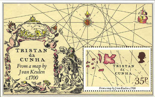
On the map the rose is at
approximately 16°S 16°W (using modern coordinates), while the Islands
are at approximately 40°S 10°W. The Islands have been moved closer to
fit the space available. The cartouche has been moved much closer to
the rose while the ship is at the correct latitude, though also closer
to the rose than on the map, and the direction lines through the rose
have been simplified.
 
 |