|
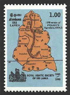
Claudius Ptolemy lived and worked in Alexandria, Egypt
during the first half of the second century ad. He created a system of
geographical knowledge that dominated the field for a millennium and a
half. The stamp commemorating the 150th anniversary of the Royal
Asiatic Society is a map of the island of Taprobana (Sri Lanka) based
on a 1378 version of Ptolemy’s map of 150 ad.
The first
printed edition of Ptolemy’s maps was published at the end of the
fifteenth century, so if the source of this map is to be dated 1378 it
is a manuscript map. A note on the map of Taprobana in the 1490 atlas
reads:
Ante Taprobanum multitudo est insularum
quas dicunt esse numero 1378
quarum, tamem nomina traduntur hae sunt.
This means that Taprobana is surrounded by
1378 islands, not that the map was drawn in 1378.
The map is roughly the shape of Sri Lanka, but it is
nearly as large as Spain and France combined. The line across the
lower part of the island represents the equator, and the numbers below
the line indicate the degrees east of Ptolemy’s prime meridian in the
Canary Islands. The shape of the island differs somewhat from
Ptolemy’s atlas of 1490.

The
Dacian people occupied lands around the Danube in the western part of
present-day Romania. Dacia was established as a Roman province by the
Emperor Domitian by war in 85-89 A.D. The Emperor Trajan continued the
conquest and commemorated his victories on Trajan's Column in Rome.
The stamp below is based on a Ptolemaic map and
represents the area north of the Danube, the blue line in the lower
left corner, and east of the present border on the west of Romania,
the red line on the left side of the stamp. Several cities are
identified; the most significant is Sarmizegetusa, which was a
Roman colony.
The stamp commemorates the two thousandth anniversary
of the founding of the city of Arad, which is located in the upper
left corner of the map.


 |
