|
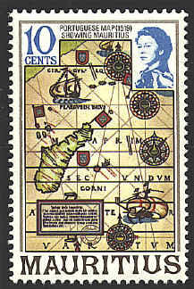
The map is
attributed to Jorge Reinel in 1520. It is probably intended to refer
to his map of the Indian Ocean, drawn about 1519 and published in the
Lopo Homem atlas, otherwise known as the Miller Atlas, 1519,
and preserved in the Bibliothèque Nationale in Paris. However, a
comparison of the map on the stamp with the relevant portion of
Reinel's map seems to show that this is not the case.
[If anyone can identify the map on the
stamp, please let me know. If you know of an image of that map on the
web, let me know that, too. Thanks.]


There are several designations that appear on
the stamp on the map. At the bottom, PREMOTORIO ben espe
is "Cape of Good Hope," which was reached in 1489. On the map of
Africa MOTE LUNE, is "Mountains of the Moon," the hypothetical
source of the Nile River. On the right side INDICVMM... is the
"Indian Ocean." On the map of Madagascar, the name SALOVRM
represents the Portuguese name for the island, "São Lourenço." None of
these appear on Reinel's map.
On the map of Africa there are also three
representations of a Portuguese flag, indicating Portuguese claims to
those territories. Similar flags do appear on Reinel's map.
The map below
shows the island of Madagascar with Mauritius to the east and colored
red, from the map of 1519.

The Angolan stamp shows Elmina in Africa on
Carta Antlantica by Jorge Reinel about 1540.

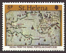
The
stamp from St. Helena shows a portolan chart of the Atlantic with
portions of North and South America on the west side. The chart was
drawn in 1530 by one of the Reinels, probably Jorge.


 |
