|
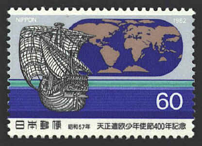
In
1582 four Samurai were sent as envoys of the Japanese feudal lords to
Pope Gregory XIII and King Philip II of Spain (who was also Philip I
of Portugal). Mansho Ito, Miguel Chijiwa, Martino Hara and Julian
Nakaura returned to Japan eight years later having studied and
observed the culture of Italy, Spain and Portugal. They brought with
them a copy of Abraham Ortelius’ Theatrum Orbis Terrarum. They
used the Typus Orbis Terrarum, the so-called oval projection,
as a model for world maps which they painted on screens.
The map is based on one of the oldest of the screens in
the possession of the Jotoku-ji (Buddhist Temple) in Fukui, on the
west coast of Honshu. the map is the same shape as Ortelius’ oval
projection, and follows quite closely the outlines of the continents,
except in Asia where Japanese information provided a greater degree of
accuracy for the coasts of China, Korea and Siberia. Japan appears
much as it does in the Typus Orbis Terrarum. Below Java
Ortelius replaced Terra australis nondum congnita by a
large island which is thought to represent the continent of Australia.
  |