|
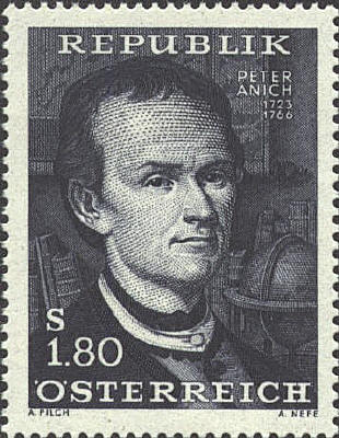
Peter Anich 1723-1766
Peter Anich (1723-1766)
was a farmer and a self-taught cartographer and engraver. He made a
large celestial globe in 1755-1756, and a companion terrestrial globe
in 1759. He made a map of the area around Innsbruck, Austria,
published in 1772, and, with Blasius Huebner (1735-1814) as his
assistant, he prepared the maps for the Atlas Tyrolensis, which
was published in 1774. The atlas contained 20 sheets engraved on
copper at a scale of 1:103,800. The stamp was issued in 1966 to mark
the 200th anniversary of his death. The portrait is similar to one
engraved by Weiss. The globe in the background refers to his globes.
It appears to be a terrestrial globe. His globes are in the provincial
museum in Tyrol. The map on the wall is probably his map of the Tyrol.

European Cities
The Austrian stamp was issued
for the 23rd International Housing and Town Planning Congress held in
Vienna in 1956. The central city plan is Vienna. The others I don't
know.

Austria
Vienna is the capital of
the Republic of Austria. In 1986 it hosted the meeting of the European
Security Conference. The map shows plan of Vienna from the Southeast.
The Danube River cuts across the upper left corner, while the Donau
Canal cuts through the middle of the stamp. The five-sided street near
the bottom of the stamp is the Ring Road
The Ringstrasse is a wide avenue which encircles the
old city. It was constructed in the late 19th century, and ever since
it has been the focal point of Vienna's city center. Within that area
St. Stephen’s Cathedral stands above the rest of the buildings on the stamp.

 |
