In 1987
Argentina issued a stamp bearing a Spanish map of the Islas Malvinas
administered by Jacinto de Altolaguirre, governor of the Islas
Malvinas from 1754-1787 for the King of Spain.

Argentina issued this stamp in 1976, still asserting it claim to the
islands. The frigate "Heroina" pictured on the stamp was captained by
David Jewet, a British subject who took possession of the
islands for Argentina in 1820.

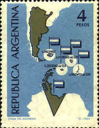
The
pair of stamps commemorates 153rd anniversary of the "Creation of the
Political and Military Command District of the Malvinas Islands," June
1829. The map identifies the Malvinas, South Georgia, and the South
Sandwich Islands as Argentine. Luis Venet was the first commander of
the Malvinas Political and Military Command District.

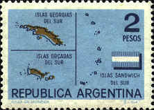
This is
the same map as 1365, but with a flag rather than a slogan in the
middle.

On both of the above
stamps (issued in 1982 and 1983) Cape Horn island was labeled as
Argentinian, and the islands of Picton, Lennox and
Nueva at the eastern entrance to the Beagle Channel are shaded like
Argentina, which almost caused Argentina and Chile to go to war in 1978.
The dispute was resolved with the "Peace and Friendship Treaty of
1984."
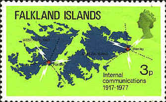
In 1952 the Falkland
Islands included a map stamp in a set of 14 stamps. It has been
suggested that there is an error on the stamp; that what appears to be
6° of longitude should be 60° or 61°. However, a close examination of
the stamp shows that the longitude is, in fact, 61°, with the "1"
directly in line with the meridian line.
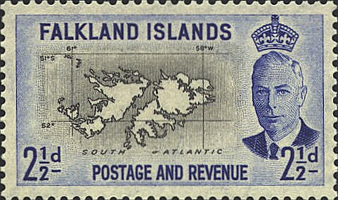
Though
the subject of the stamp is International Communications rather than
the border dispute, an implicit territorial claim is being made by
issuing a map stamp.
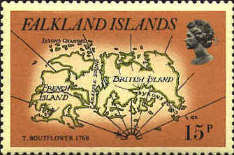
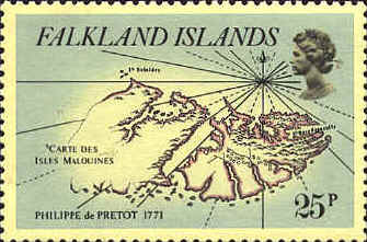
In 1981
the Falkland Islands issued a set of six stamps showing maps of the
Falkland Islands from 18th century. They appear here in chronological
order of their publication.
This map is adapted from A Chart of the extreme Part
of South America in which are contain'd the Islands discover'd by the
Ships of St. Malo since 1700 the Western Part whereof is Still
unknown....Taken from a Draught in Monsr. Frezier's Voyage to ye Sea,
first published in 1716. The chart was used as an inset on
Emanuel Bowen's A New and Accurate Map of Chili, Terra Magellanica,
terra del Fuego, etc., London, 1747.

Louis Antoine de
Bougainville took possession of the islands in 1764, and established a
French colony at Port St. Louis. Jacque Nicolas Bellin used survey
information to draft a map, Carte des Isles Malouines ou Islaes
Nouvelles que les Anglois nomen aujourd'hui Isles de Falkland,
which was published in Bellin's Petit Atlas Maritime in 1764.

T. Boutflower published a
map in 1766. in which the British and French changed their islands.
Philip de Pretot's Carte
des Malouines nommees par les Anglois Isles Falkland appeared in
Louis Antoine de Bougainville's Voyage autour du Monde,
published in 1771.
The map
is based on A Chart of Hawkin's Maidenland discouvered by Sr.
Richard Hawkins in 1574 and Falkland sound so called by Capn. John
Strong of the Farewell of London who sailed through it in 1689,
which appeared in Hawksworth's An Account of the Voyages undertaken
by the Order of his present Majesty for making Discouveries in the
southern Hemisphere, and successively performed by Commodore Byron,
Captain Wallis, Captain Cartaret and Captain Cook, published in
1773.

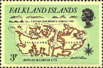
The English established a
colony on the west island in 1765. In 1766 Captain McBride prepared a
chart based on his surveys of the islands. The map identified as
Captain McBride's Survey 1766. It was published by Bowles and
Carver in 1779 as New One Sheet Draught of Falklands Islands.