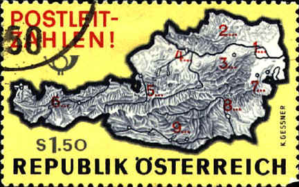
| The Austrian
stamp was issued in 1966 to mark the introduction of postal zone
numbers, which appear on the stamp. The zones are as follows: zone
1-Vienna, 2, 3-Lower Austria, 4-Upper Austria, 5-Salzburg, 6-Tirol and
Vorarlberg, 7-Burgenland, 8-Styria, 9-Carinthia. The lines on the map
are rivers, not the boundaries of the postal zones. The three dots
following each zone number represent the 3 additional numbers in the
postal code.
The map
of the postal zones of Hungary was issued in 1973 to mark the
introduction of the postal code system.

The
Czechoslovakian stamp was issued in 1976, and shows postal code
numbers on the map.

The
booklet cover from Sweden was issued in 1977. It shows a map of
Stockholm with public transportation routes. The stamps in the booklet
(SCN 1220-1224) show various kinds of public transportation.

The map
shows the Romanian telephone network.

In the
middle of the 19th century Charles Bontemps, a French engineer,
experimented with pneumatic technology for the transmission of the
mail. The earliest pneumatic postal networks were in London, Paris,
and Berlin in the late 1860's. The system in Paris was begun in
1865-1867. The Seven Weeks War (1866) and the Franco-Prussian War
(1870) prevented full scale development.
Non-continuous air flow through one-way tubes was used
to propel "trains" of carriers at 15 minute intervals. The system
continued to expand in the period from 1871 to 1918. In 1907 over nine
million items were transmitted. By 1982 the number fell to less than
650,000 and the system was closed in 1984.
The stamp may reflect the actual system at some point
in its history, or a part of that system, or it might simply be an
impression of the principles..

 |
