|
Inō Tadataka
(Inō Chūkei) (1745-1818) was born in
Kazusa Province in 1745. He was adopted as the heir of the Inō family
in the city of Sawara. He managed the family brewery until he was
fifty. After he retired he began to study astronomy, geography and
mathematics and began drawing maps. Between 1800 and 1816 he spent
3,736 days taking measurements and mapping Japan. His maps are
accurate to about a thousandth of a degree.
Tadatakaís maps were not completed during his lifetime.
In 1821 the Dai Nihon enkai yochi zenzu, an atlas of Japan based on
his surveys was completed. The atlas contained 214 sheets on a scale
of 1:36,000, 8 sheets on a scale of 1:216,000 and 3 sheets on a scale
of 1:432,000.
Though Inō's maps were not in use during the Edo
period, they were made the standard maps of the country in the Meiji
era. Maps published by the British Navy in the 1860ís were based on
Inōís maps, and maps based on Inōís were used as late as 1924 by the
Japanese military.

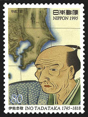
The
stamp was issued in November 1995 to observe the 250th anniversary of
the birth of Ino Tadataka. The map depicted on the stamp is a portion
of a map attributed to Tadataka. The map shows an area centered, more
or less on Edo (now Tokyo), and shows the province of Kazuza where
Takataka was born. The city of Sawara is slightly north and just west
of the the point on the right of the land in the map. The portrait of
Tadataka is from a contemporary painting.


 |
