|
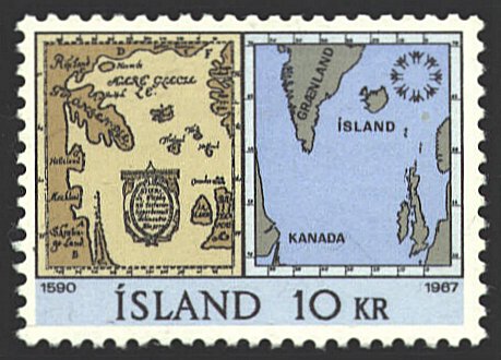
This map was drafted by Sigardur Stefansson of Iceland in 1579. The
original has been lost. The map on the stamp is based on a copy made
by Theodore Thorlacius in his Compendiosissima Descriptio
Chronographica, Topographica & Chronologica published in 1669. It expresses the ancient idea that land
surrounded the ocean, instead of the ocean surrounding the land. It
embodies information which existed in the Skåholt monastery in Iceland
at the time the map was drawn. The map locates place names by
degrees of latitude, which allows us to identify the contemporary
headlands and bays. It was another century before the accuracy of this
map was improved on.

If you look closely at the map you will see
alphabetical references. They provide an index to the various features
of the map. |
|
A This is where the English have
come and has a name for barrenness, either from sun or cold.
B This is near where Vineland lies, which from its abundance of useful
things, or from the land’s fruitfulness, is called Good. Our
countrymen have thought that to the south it ends with the wild sea
and that a sound or fjord separates it from America.
C This land is called Rüseland or land of the giants, as they have
horns and are called Skrickfinna (Finns that frighten).
D This is more to the east, and the people are called Klofinna (Finns
with claws) on account of their large nails.
E This is Jotunheimer, or the home of the misshapen giants.
F Here is thought to be a fjord, or sound, leading to Russia.
G A rocky land often referred to in histories.
H What island that is I do not know, unless it be the island that a
Venetian found, and the Germans call Friesland. |
| The map on the right
side of the stamp shows the same area from a modern perspective.
Kirsten A. Seaver, "Renewing
the Quest for Vinland: The Stefansson, Resen, and Thorlaksson Maps,"
Mercator's World September/October 2000, pp. 42-49.


 |
|
