|
The São Francisco River is the fourth longest river system in South
America, and, at approximately 1,800 miles, the longest river that
lies completely within Brazil.

The
stamp issued by Brazil in 2005 shows a simplified image of the river
system. There are four red areas on the main stream. Three of them
mark the locations of three large dams, Tres Marías, Sobradinho and
Paulo Alfonso. Tres Marías, near the southern end of the river, was
completed in 1961, Sobradinho or Itaparica Reservoir, just west of the
northern-most point of the river, was filled in 1988, Paulo Alfonso is
located at the Paulo Alfonso falls (over 250 feet high) at the north
end of the river ,(the large red area east of the north-most point.
The dams provide hydroelectric power, urban and industrial water, and
water for agriculture. The red area east of that is unidentified.
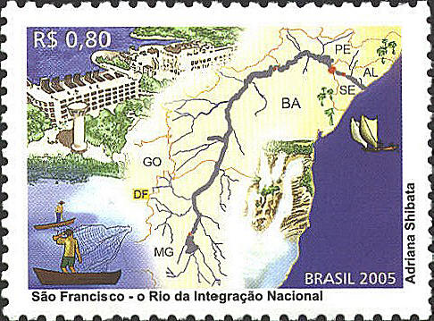
On the stamp there are
pictures of a hydroelectric plant, people fishing, a waterfall, and a
couple of boats in the ocean. I believe the waterfall is the Paulo
Alfonso waterfall. The letters on the map indicate seven Brazilian
states: PE-Pernambuco, AL-Alagoas, SE-Sargipe, BA-Bahia, GO-Goiás,
DF-Distrito Federal, MG-Minas Gerais.

|