|
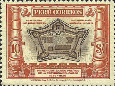
Callao ~ 1746
Callao
was founded by Francisco Pizarro in 1537. It was the main shipping
point for silver and gold taken from the Incas by the conquistadors.
The stamp shows a plan of the city as it was just before the
earthquake of 1746. On the wall surrounding the city there were
thirteen bastions, eight on the land side, and five on the side facing
the sea. They were named beginning in the lower left-hand corner and
reading clockwise: San Miguel, San Ignacio, Santa Cruz, Santa
Catarina, Santiago, San Juan, Santo Domingo, San Felipe, San Luiz, San
Lorenzo, San Francisco, San Pedro, and San Antonio. The buildings in
the center of the city were cathedrals, whose names were from left to
right, La Mercea, San Francisco, Santo Domingo, Matriz, and San
Augustino. The viceroy's palace is just below San Augustino.
The city of Callao was destroyed by an earthquake and tidal wave in
1746.

The Fortress of King Philip
The stone fortress
was built facing the Pacific Ocean between the years 1747 and 1766 by
the Spanish to defend the colony from pirates. It was designed by the
architect Luis Gaudin and finished by the Viceroy Amat in 1773. It was
named in honor of the first Bourbon king of Spain. It was built in a
pentagonal shape with five bastions.
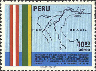
The Amazon Basin
The stamp was issued in
honor of the state visit of General Ernesto Geisel, President of
Brazil in 1976. The map shows the Amazon basin. The dotted line
represents the border between Peru and Bazil. The area between the two
dotted lines North of the Amazon River indicates Colombian territory.
Three rivers flow into the Amazon, from the left, the Maranon, the
Huallaga, and the Ucayli. Three towns or cities on the Amazon are also
marked, from the left, Iquitos, Peru, ?, and Tabatinga, Brazil.

 |
