|
In 1550 Pierre Descaliers,
a priest living in Arques, a village near Dieppe, and the “father of
French cartography,” created his masterpiece, Faicte a Arques par
Pierres Descaliers p[res]b[yt]reian: 1550. It portrays parts of
Mexico, Central and South America. The Straits of Magellan are noted
as are the Amazon River, in a primitive form, and the Rio de la Plata.
Several towns, groups of people, ships and other pictures decorate the
map. A portion of North America is also visible.
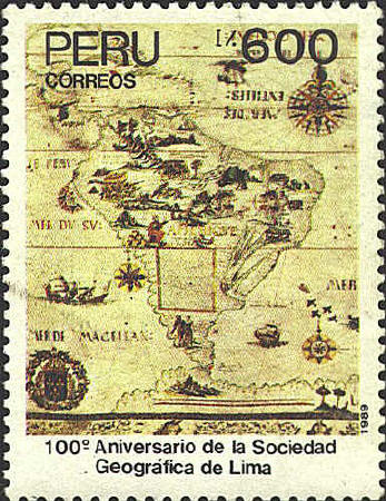
Descaliers’ map was
dedicated to Henry II, King of France, Grand Constable de Montmorency
and Admiral Claude d’Annebaut. It was intended to enlighten the court
on the state of the world as it was known in 1550. In keeping with
that purpose it is the most carefully drawn and richly decorated and
illustrated of Descaliers’ maps.
Parts of the North American portion of the map appear
on the stamp from Great Britain which honors Martin Frobisher, who
sailed to North America three times in the 1570's, and gave his name
to Frobisher Bay near the entrance to Hudson Strait on Baffin Island.


 |