|
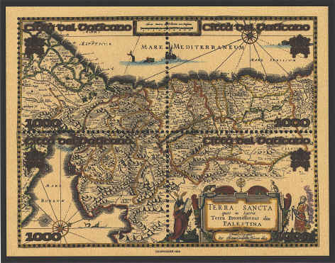
Terra Sancta quae in
Sacris Terra promissionis olim Palestina has a series of vignettes
which enable one to accompany the Israelites on their Exodus out of
Egypt, across the Red Sea. Following the pillar of cloud and of fire
they travel to Sinai where Moses stands on top of Mt. Horeb holding
the tablets of the Law, while the Israelites dance around the golden
calf below. Sinai is about one-third of the height and width of the
map on the lower left. After an abortive attempt to enter the land the
people spent forty years in the wilderness. At. Mt. Nebo Moses died,
and the Israelites crossed the Jordan River to inherit the land
promised by God. Nebo is just to the left of the lower edge of the
Dead Sea, while Jerusalem is above and to the left of the center of
the map.
The compass rose at the top indicates the orientation
of the map. The figures beside the cartouche are Moses on the left
holding his rod and the stone tablets of the Law, and Aaron in
priestly garb with the breastplate of Urim and Thummim, holding a
censer
The map was drawn in 1629 and was
incorporated into Joan Blaeu’s (c. 1599-1673) Atlas Minor, 1662-1665.
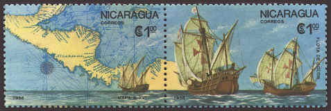
The pair of stamps
reproduces part of William Blaeu’s (1571-1638) map Insulae
Americanae in Oceano Septentrionali cum Terris adiacentibus
, first published in 1634
and later in Joan Blaeu’s Groot Atlas in 1662. Since the map was first
published in 1634, the note on the lower right hand corner of the left
hand stamp, “Mapa S. XVI” is incorrect.
Blaeu’s map was based on the regional maps of the
Americas by Johannes de Laet (1593-1649). in 1630 in the volume L‘Histoire du
Nouveau Monde ou Description des Indes Occidentalis which included 14
maps drawn by Hessel Gerritsz (1580/81-1632).
"For 23
years Andreas Bureus, on the basis of material from the Royal
Chancellery, worked on the wall map Orbis Arctoi which
was completed in 1626. Subsequently he was engaged in Swedish land
surveying. In 1635 his map was copied at Amsterdam for an atlas by
Willem Blaeu, whose son Joan incorporated this version in the finest
Atlas of the time, Atlas Maior in 1662."


 |