|
Theoretically a degree
of latitude is a constant, the same at the equator as at the pole.
However, Isaac Newton believed that the earth was slightly flattened
at the poles, an oblate spheroid, and that the length of a degree at
the poles was longer than it was at the equator. On the other hand
French mathematicians argued either for a perfect sphere or for a
prolate spheroid, one which bulged at the poles.
The French Royal
Academy of Sciences determined to settle the matter by sending
expeditions to the Equator and to the Arctic Circle. If the length of
a degree were longer at the Arctic Circle than at the Equator the
spheroid would be oblate, flat at the poles; if it were shorter,
prolate, and if the degrees were equal, then the earth would be
spherical.
In 1735 the French Royal Academy of Sciences sent out
two geodetic expeditions to determine the length of a degree at the
pole and at the equator. The expedition to the Arctic Circle was under
the leadership of Pierre-Louis Moreau de Maupertuis went to the Arctic
Circle. The one to the Equator had Charles Marie de La Condamine as
its chronicler. Near Quito, in what is now Ecuador, a base line was
established by triangulation, and the length of the degree of latitude
was measured.
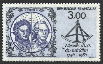
Although the expedition to the Equator left in 1735, a year earlier
than the one to the Arctic Circle, it did not report is finding to the
Royal Academy until 1744, nearly eight years after the northern
expedition had made its report. In both cases the results were clear:
the earth was not a perfect sphere. It was flattened at the poles.
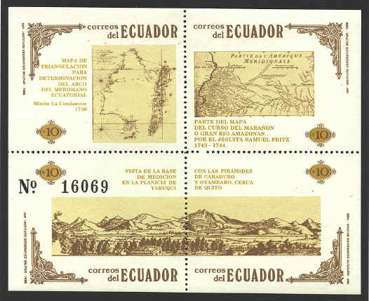
The map in the upper left
quarter of the sheet shows the map of the triangulation by which the
length of the degree was determined. The other map shows the course of
the headwaters of the Amazon River by the Jesuit priest, Samuel Fritz.
Fritz established a number of mission stations among the Omagua from
1687 to his death in 1723. This map was the first of any real accuracy
ever made of the river, though it, too, had mistakes. La Condamine
acquired a copy of Fritz’ map and corrected many of the mistakes. The
dates given for Fritz on the stamp are incorrect.

Pierre-Louis Moreau
de Maupertuis (1698-1759) led the expedition of four to Lapland. At
Stockholm they were joined by a Swedish astronomer. They arrived at
Torneå, at the northern end of the Gulf of Bothnia in early summer.
With the church spire as their starting point they plotted a series of
triangles north to Kittis mountain. After determining the angle of a
known star at Kittis and at the church in Torneå, they measured the
distance between Kittis and Torneå to determine the length of a degree
at the Arctic Circle.
Although his measurements were not absolutely accurate,
the length of a degree at the Arctic Circle was nearly half a
kilometer longer than in France, proving that the shape of the earth
was an oblate spheroid.
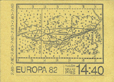
The map on the Swedish booklet
cover is based on Maupertuis’ map in his report to the French Academy.
For
further information on the work of Condamine see the article "Degree of
Difficulty," by David Taylor in Mercator's World, May/June
1999, pp. 18-25. |